The enigmatic history of the Paya on the Bay Islands leaves us in many ways with more questions than answers despite having been the subject of a dozen archaeological expeditions during the 20th century and a couple in the 2000’s. There are remains and sites scattered all over the three islands but personally I am most familiar with the erstwhile Paya community of Masa , as St. Helene was known as by the Indians. The following layman’s study ( I am not an archeaologist , merely an amateur enthusiast )focuses primarily on Masa and its possible important significance within the wider Paya ( todays Pech ) civilization and to its people. It’s uniqueness is due to the variety of pottery and antiquities that have been found over the years , the extensive cave systems ( at least 29 caves of which several have not been explored to their full extent )and it goes without saying due to the attraction it held over early explorers , adventurers and archaeologists.
Overview
Pech Indians have been living in Northeastern Honduras ( including the Bay Islands )since 300AD . This area ( figure 1 , below )around Trujillo and parts of the Aguan valley and as far east as the Mosquitia , as far south as Olancho and as far north as the Bay Islands . We will refer to the Bay Islands Pech ( the first and only autochtonous inhabitants of the Islands ) as the Paya ( Paia ). Little is known about their leadership , beliefs and movements however existing sites in the region offer us a glimpse into the peaceful way of life that they led for nearly a thousand years before the arrival of the first Europeans. One of these sites is the Selin Farm site , located on land belonging to the Standard Fruit Company. In the 1930’s ( Bird and Strong ) 1957 ( Epstein ) the 1970’s ( Healy ) and more recently in the 2000’s ( Cuddy and Goodwin ) , several mounds of stratified deposits were found which served as a type of time capsule providing glimpses of occupation over a period of approximately 700 years. Radiocarbon dating was conducted by Archaeologists on the deposits ( clay pot shards , shells ) and a timeline arrived at to be able to classify the samples into Early Selin AD300 to 600 , Basic Selin AD 600 to 800 and transitional Selin AD800 to 1000. Based on this system of classification , we are able to get an idea of the Paya peoples in the Bay Islands and particular on Helene.
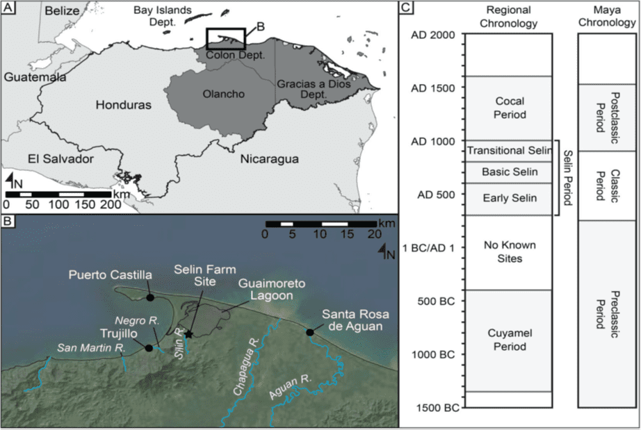
Figure 1: Regional Chronology showing pre-columbian Pech ( Selin and Cocal ) civilization and post 1502
Archaeological studies and subsequent radiocarbon dating done on pieces now housed in the British Museum and Smithsonian have also demonstrated direct similarities between the Selin Farm mound samples and sites on the Bay Islands ( Utilas 80acre site , Guanaja Plan Grande site , ceramics from Indian Hill on Masa ) . On Columbus’s fourth voyage in 1502 he sent his brother Bartholomew and 14 year old son , Ferdinand ashore at Guanaja ( know as Wa-Na-Ha in Paya) together with Peter Martir and a Sr. Porras and who documented what we now as the first interaction between Europeans and Indigenous Bay Islanders. Each one of them made notes which also serve as a glimpse into the Payan civilization.
General Classification of Bay Islands Paya sites
According to William Davidson in his 1974 book , “ A Historical Geography of the Bay Islands , Honduras “ , Pre-Columbian sites can be classified into three types : Ceremonial , Residential , Offertory , Burial and Unknown.
In the Bay Islands , only two Ceremonial Sites have been identified thus far ; the first , in Utila the stone causeway system which is said to have astronomical significance and the Plan Grande site in Guanaja ( Wa-Na-Ha) with rock carvings on moniliths and a large stone wall surrounding the area which were mapped three times in the late 1930’s by Mitchell-Hedges , Duncan Strong and William Feacham. It is my personal opinion based on my research and findings that Masa ( today’s St.Helene ) had ceremonial as well as spiritual significance and could have been one of three of the Idol sanctuaries in the entire Paya civilization , but more about that later.
Residential sites are scattered all over the three islands with the largest being in Utila ( 80acre site – which is spread out over 40acres ironically ) and in Plan Grande , Guanaja adjacent to the ceremonial site. These sites have been identified by ‘kitchen’ mounds or heaps with sherds of scattered pottery and the occasional conch shell. The evolution of these residential sites or settlements over the 1300 years of Payan permanent presence is addressed in our focus on Helene later in this article.
Offertory sites are small areas with no visible monuments but contain deliberately destroyed and broken artefacts such as pots , metates , clay figures , conch shell trumpets and flutes ( ocarinas ). All offertory sites are located on hilltops , the largest being mid island on Roatan ( Antegual ) and Barbarat ( Indian Hill ).
Burial sites are scattered all over the 3 islands and are mostly whole families ( adult skulls as well as children ) either on the beach ( such as in Utila ) with slate rock covering the graves and on hilltops with a layer of beach sand. Duncan Strong found evidence of human burials in a cave on Helene in 1935 as have caver Amilcar Herrera and I on Helene in recent years.
More than twenty five sites have been found on Roatan with evidence of aboriginal occupation whose purpose or function is Unknown this includes the caves on our Possum Island ……. Masa
Life on Masa 300 to 1600AD ………. A separate Island if you please
According to the Spanish Governor and Captain General of Honduras , Francisco de Avila y Lugo in a report in 1639 , the island we know today as St. Helene was called Masa ( Opossum ) which would make sense since Opossums ( or possums ) are commonly encountered in the forests on Helene. What we do know about Helene ( Masa ) is that the caves held a spiritual or ritualistic significance to the Paya population in the Northeastern Honduras as a whole. Indian Hill ,the highest peak on Masa shows evidence of a large residential settlement according to William Feacham who visited the site in the summer of 1939 … “ situated in a corrie facing south, and beneath it lie fertile slopes which could easily support a large population “
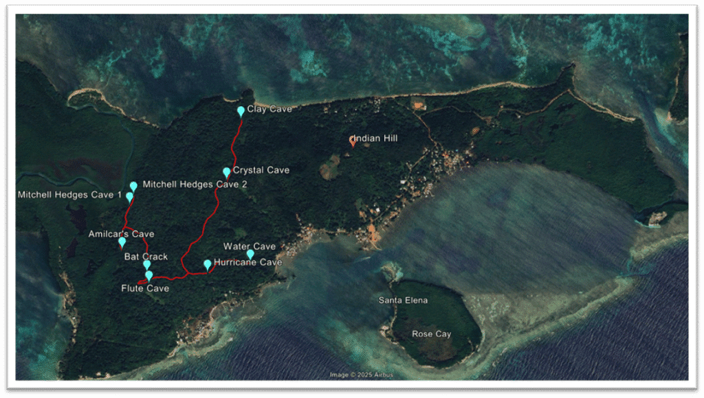
Figure 2 Image of Masa showing Location of Indian Hill ( residential settlement )and the location of 9 caves
The Indian Hill settlement is spread out over about 4 acres and supported a population of approximately 100people. We are sure that the Paya lived here for at least 1000 years due to radiocarbon testing of the pottery urns and ollas found here by Lord Moyne and William Feacham in 1938 and 1939 , a few pieces have been dated back to the early selin period of AD300 to 600 which would take us back 1200 years prior to Columbus’s fourth voyage . Significantly also is the conch shell heaps or evidence thereof that show the progression of the Payans living initially close to the sea ( AD300 to 600 )and later on during the basic and transitional Selin periods ( AD600 to 1000) when agricultural methods were modified and advanced they moved to higher ground. This move allowed them to be free from the mosquitos and sandflies , cooler weather conditions with sea breezes and a defensive advantage which would allow them to see great distances out to sea both north and southwards. There is evidence that the fertile slopes that Feacham alludes to in his 1939 report were terraced and cultivated ( most likely cassava ).
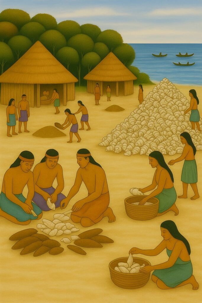
Figure 3 : A sketch which shows how an early Selin settlement would have been situated next to sea before moving to the hills. Huts constructed of locally cut materials ( cohoon palm and palmetto leaf for thatch and bamboo , oak and white mangrove for structure ). A conch shell heap being an important landmark of the settlement since conchs were a staple and the shell used to make trumpets , jewelry and implements. The peeling of cassava for meals and to make the fermented beer was an activity performed by the men. Beans and peas are being sifted by women and children. Men dedicated most of their time to fishing and turtling in crudely carved canoes from large tree trunks.
During both of Lord Moyne’s visits in 1938 and 1939 following in Frederick Mitchell-Hedges’ footsteps from his 1928 pillage of the Island , entire pieces and sherds of polychrome pottery were found that indicate that trade had been conducted with peoples from the Ulua valley ( Mayans ) , either this or Mayans visited for some reason , possibly spiritual. Payan pottery was very simple and monochrome ( no colour besides the orange of the clay ). It is a common misconception that the Paya lived in the caves in Masa , actually they lived in open air palapas thatched with the plentiful cohoon palms abundant on the island. Later during the Cocal period ( AD1000 to 1600 ) , wild cane walls were threaded and plastered crudely with the abundant red clay using the Bahareque technique.
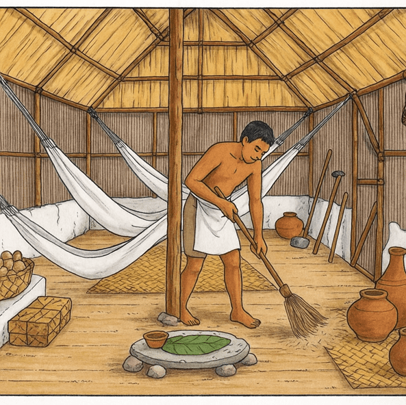
Figure 4 : The inside of a Paya hut shows ollas ( for water ) and a metate for grinding corn and other stables. Hammocks were common for sleeping as well as the well known woven petate ( on the floor )
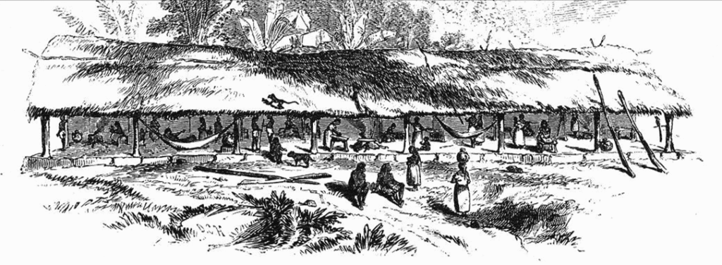
Figure 3 : A sketch of a Pech ‘Longhouse’done by EG Squier in 1858 ( at Trujillo )similar to the longhouses in Paya settlements on the Bay Islands ( AD 300-1600)
We get a glimpse of the Paya world through the eyes of the first European visitors in 1502 with the arrival of Columbus at Wa-na-ha whose brother Bartholomew observed that the Indians were “a very robust people who adore idols and live mostly from a certain white grain from which they make fine bread and the most perfect beer “.
In 1639 , the President of the Audiencia of Guatemala ordered Don Francisco de Avila y Lugo , governor and captain general of Honduras , to report to him on the islands and their condition , in which he wrote :
“ There are four towns of Indians in the Guanaja Islands , namely , Guanaja , Masa , Roata , and Utila . These islands them- selves may be best described in their order from east to west . The first , in lat . 16 ° 30 ′ N. , and long . 61 ° W. from the Azores , is Guanaja , from which the others of the group have received the generic name of Guanajas . The second is Guayama , called by most cosmographers Aguaiciva , and by the Spaniards and Portuguese Masa and Roata , from two towns of Indians , which are separated , as is also the island itself , by a narrow canal not ad- mitting of navigation , even by vessels of the lightest draft , so that the two parts are considered as one island . The third principal island is Utila , which contains the fourth town above- mentioned . Collectively , these islands at present contain about 120 tributaries , more or less , or , including women and children , about 400 souls. ”
This is significant as far as Masa goes , suggesting its importance in the Pre- Columbian Bay Islands , in as much as the 1639 report was written after the arrival of the first Europeans and Masa ( and indeed Utila and Plan Grande in Guanaja as well ) had to have been key for it to have survived 137 years of slave raids and harassment by pirates. De Avila y Lugo’s report clearly mention the geographical location of Masa ( Helene ) separated by the mangrove canal and mangroves from Roata . The closest evidence of settlement west of Masa would be the settlement at the place we know today as Pulpit or Pulpit Rock where Feacham found the 20 foot long slab which had 44 holes in it , 4 inches deep which might be artificial ( man made )so we can safely surmise that Roatá is where Pulpit rock is today.
Masa ……..a significant shrine site ?
One of the first and most important pieces of ethnohistoric information available on the Bay Islands comes from a report ordered in 1527 ( more than a 100 years prior to de Avila y Lugo’s report ) by Governor Diego López de Salcedo on the customs and religion of the Pech . This report found that there existed in this region three main idols which were worshipped inside temples:
“…one four leagues from Trujillo, the other in a town thirty leagues away,
and the third on an island fifteen leagues from this city. They were shaped
like a woman and were carved from a greenish marble-like stone. To these
they gave all of their devotion and entrusted their affairs and duties, so that
they would guard them from bad weather and adversities. And they also
had other idols and places of worship where they made their sacrifices.
Each of the three main temples had a person called a Papa, who could not
marry, and had hair so long that it reached his waist, and had with him the
sons of gentlemen to indoctrinate them. “
The temple that contained the third idol could well have been located at either the Plan Grande Site in Wa-Na-Ha ( Guanaja ) or indeed in Masa since both of these sites fall within fifteen leagues ( or 51 miles ) from Trujillo. What we do know based on accounts of the Spanish conquistadores and also Priests is that shrines were permanent in nature , while the hamlets would change location according to season or necessity. Burial methods also varied , Franciscan monk Fernando Espino in the 1600’s during a stay in Trujillo to study the Pech tongue observed that burials were sometimes done with the deceased laying in a canoe , other burials he observed were done with an upturned canoe on top of the body. In Utila on the beach at Black Rock , skulls and bones likely belonging to a whole family were discovered by Junius Bird ( 1933 ) and could have been related to an accident or indeed human sacrificing comes to mind ; after all this was common practice in Maya civilization on the mainland.
In Masa , Human remains have been found to a limited extent inside the many caves but nothing similar to the family site in Utila. One thing is a constant though is that whole pieces of offertory type pottery or fragments have always been found close by. Edouard Conzemius was a timber merchant from Luxembourg who travelled extensively throughout the Moskitia , Northeastern Honduras as well as the Bay Islands around 1926 ( even before Mitchell Hedges ) . He studied the contemporary Pech people and upon visiting the Bay Islands including Masa ) noted evidence of the broken pottery sherds , showing the deliberate breaking of pots and effigies , both in the caves as well as in the open at residential areas such as Indian Hill . He drew a parallel with the Pech practice of breaking a deceased person’s possessions to liberate their soul to the afterlife so their spirit would not stay to haunt the living. In the 1990s a cave was discovered on the western side of Masa and close to the entrance of it was a male skeleton , mostly intact slumped over as if this person had been deliberately sat there for burial. Significantly was the amount of jade and copper bells ( cascaveles ) found within the skeleton and strewn close by as if he had on necklaces , bracelets and adorned headbands. At first , the locals who found the site and subsequently took away the beads and bells to sell as ‘yaba ding ding’ assumed him to be some sort of chief however it is highly likely that he was a holy man or Wata ( Papa as the Conquistadores referred to him ) . If the remains were those of a Wata , this would indicate that Masa was indeed one of the three sacred Shrines.
Another indication , in my opinion that Masa could have been one of the three sacred Pech shrines were the four clay effigies found at the Indian Hill site by Lord Moyne ( Arthur Guiness ) on his first expedition to Masa with William Feacham in 1938. Each one is the same : a female covering her breasts with her hands , an elaborate headdress and necklace , double ear piercings and kneepads.
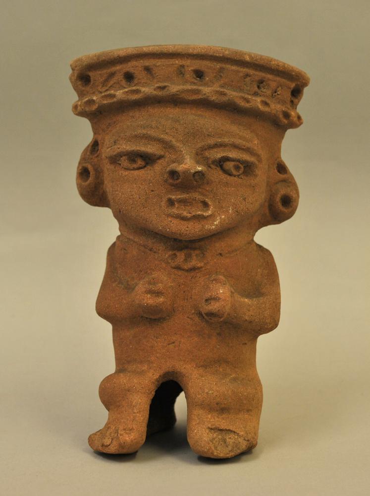
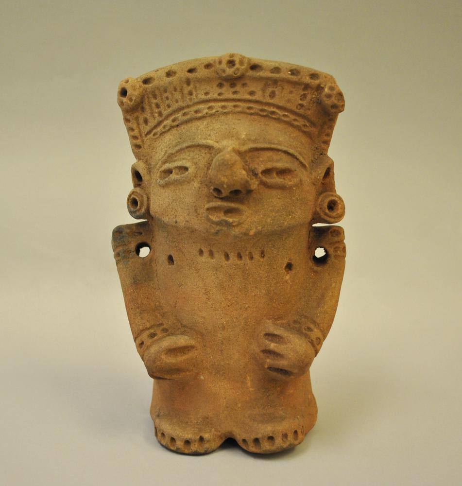
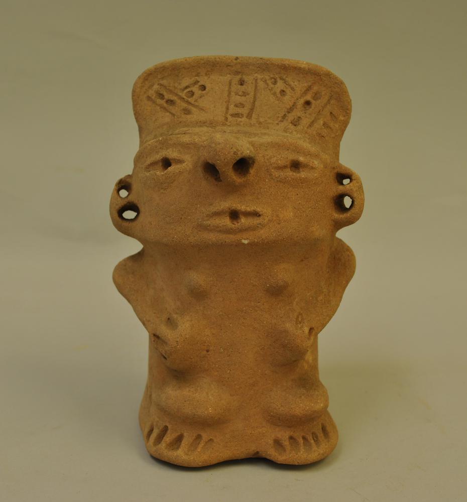
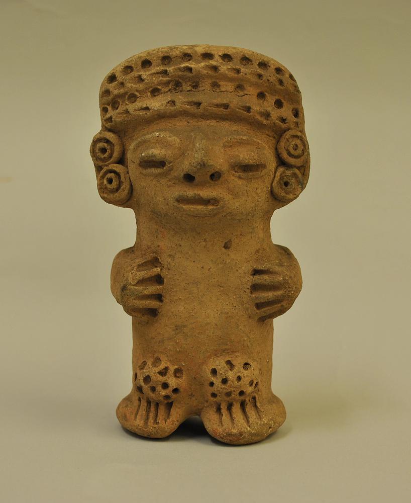
Figure 4 Four clay anthropomorphic figurines dating back to the early Selin period ( AD300-1000 )found by Walter Edward Guinness ( Lord Moyne )in1938 and displayed in the British Museum
If we go back to Lopez de Salcedos report of 1527 :
“…..They ( sic – the idols ) were shaped like a woman and were carved from a greenish marble-like stone. “
He explains briefly about the appearance of the idols located at each of the three shrines. Could the 4 figurines found by Lord Moyne have been small replicas of one the idols , perhaps located at Masa and available for pilgrims to acquire through bartering as souvenirs ?
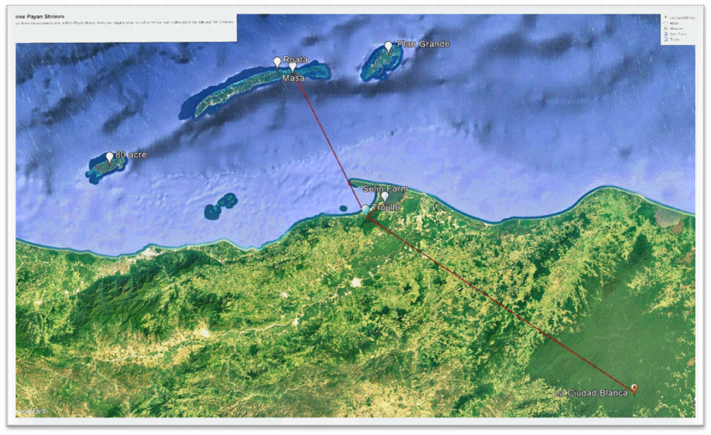
Figure 5 shows the 4 main Paya settlements In the Bay Islands and the possible location of the three main shrines based on references in de Avila y Lugos 1527 report ( a ‘town 30leagues away’ – Cuidad Blanca , ‘four leagues from Trujillo’ – Selin and an island 15leagues away – Masa /Helene)
Yet a further reason that leads to me believe that Masa was the third Shrine sanctuary is the evidence of incense burning ‘chalices’ formed out of stalagmites or perfectly formed round holes inside several caves on Helene ; in fact in most of them have thick ingrained carbon residue indicates that these structures ( ranging between 6 inches to a foot high ) had been used consistently during the 1000 odd years of the Paya era. Some have a grass like material still in the cup.
The photographs below were taken inside a cave that was recently discovered just a year ago. The cave ( we have named Amilcar’s Cave ) is very difficult to identify and the entrance is executed by absailing back first , down a 40 foot opening at the top of a limestone plateau. The cave has several shafts running horizontally outwards from the main entrance ‘hall’ and bits of broken pottery have been found in this hall as well as the above mentioned chalices. This particular cave has been untouched by human hand since Payan’s lived on Masa ……. Some 400 years ago at least.
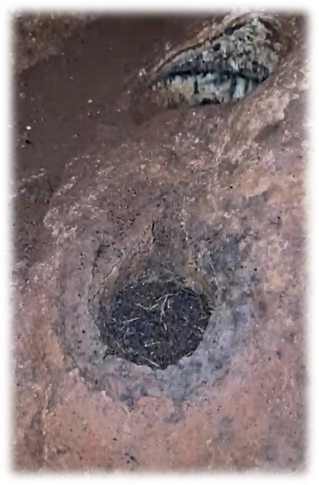
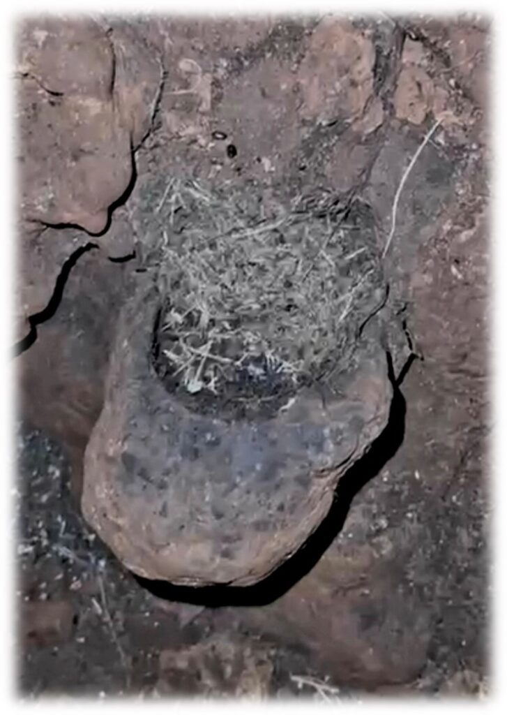
Figure 6 : strange formations on a cave floor in Helene ( Masa ) that resemble Incense holders
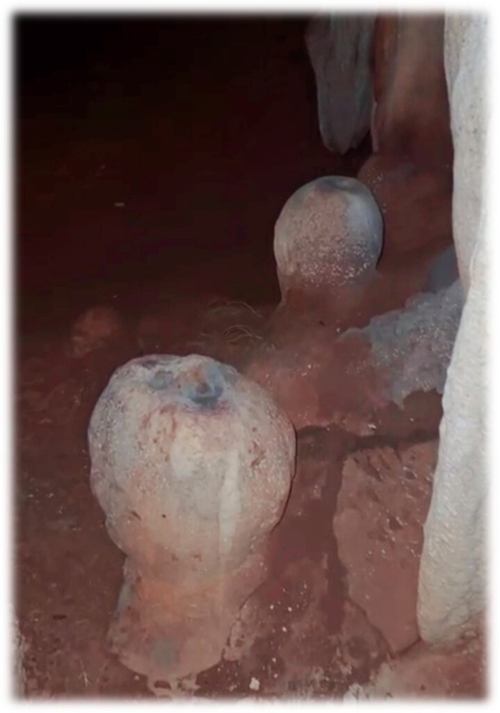
Figure 7 eerie looking spheres with openings on the top with signs of carbon having been used possibly as incense burners
Figure 7 a portion of Duncan Strong’s journal where he makes note of ‘ life-size human forms with a rounded head’ similar to the spheres I encountered in Amilcar’s cave
The world outside Masa ………Mesoamerica
When I first lived in Helene in the eighties , I can recall the childish glee which villagers would greet the arrival of crafts from the mainland ( called canoas by the Spaniards ) , loaded down with plantains , oranges , bananas even cows or hogs if you arranged it with them. That was then nowadays we have ferries and speedboats and planes in abundance .
Hundreds of years before me , the Paya of Masa must have been equally as gleeful to see incoming craft from the south ( around Trujillo ) , the west ( Ulua River mouth ) and maybe even further from the Yucatan bearing trinkets . We know there was trading and visiting from Chorti-Mayan Indians and mainland Pech not only from the accounts of Bartholomew Columbus but also from physical evidence of pottery and trinkets that have been found on the island . I have found polychrome sherds and fragments of burial urns that evidently were made in the Ulua valley judging by the material they were made with as well as the colour. It has been much debated among archeologists since the 1920’s , when the Bay Islands first began attracting attention , as to whether or not Mayan Indians from as far away as the Yucatan traded in the Bay Islands. It is most likely , according to Duncan Strong in 1935 that since the Ulua valley was a heavy producer of Cacao and closer to the Yucatan that it received visits from Mayan traders who exchanged cloth , brass trinkets like bells , implements for Cacao. It is then highly likely that these Chorti-Maya from the Ulua in turn traded these trinkets with Bay Islanders in exchange for seafood ( turtles , conch , fish and lobster ) or other such rarities.
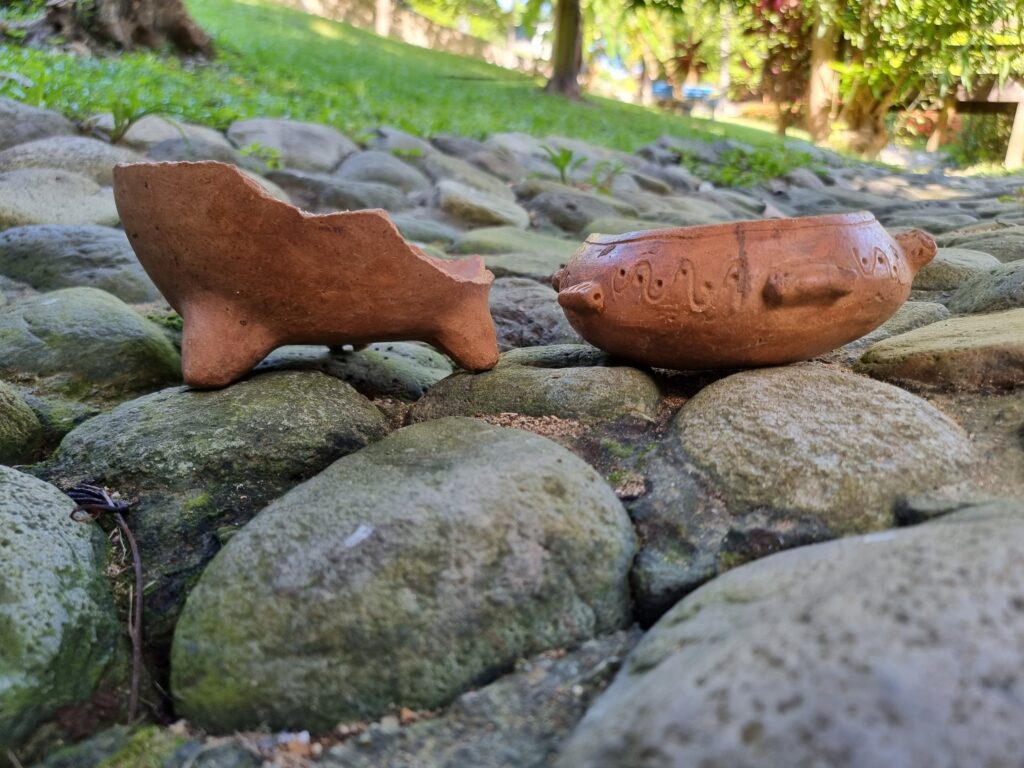
Pottery , mostly pot (or olla) handles and some legs for the ollas were fashioned after wildlife indigenous to North Eastern Honduras but not necessarily the Bay Islands. Common animals are the Tapir ( common to Olancho – the extent of the Pech territory ), monkeys , spiders , parrots and common manatees. The prevalence of pottery with these indigenous mainland animals tells us that most of the ceramic work came from the Pech corridor on the mainland either through trading or for burial purposes . Some very clean plumbate coated pieces were found in a small cave indicating that the pieces were brought from the mainland ( likely Ulua Rivermouth ) specifically for a burial ( teeth and a jawbone were found nearby )
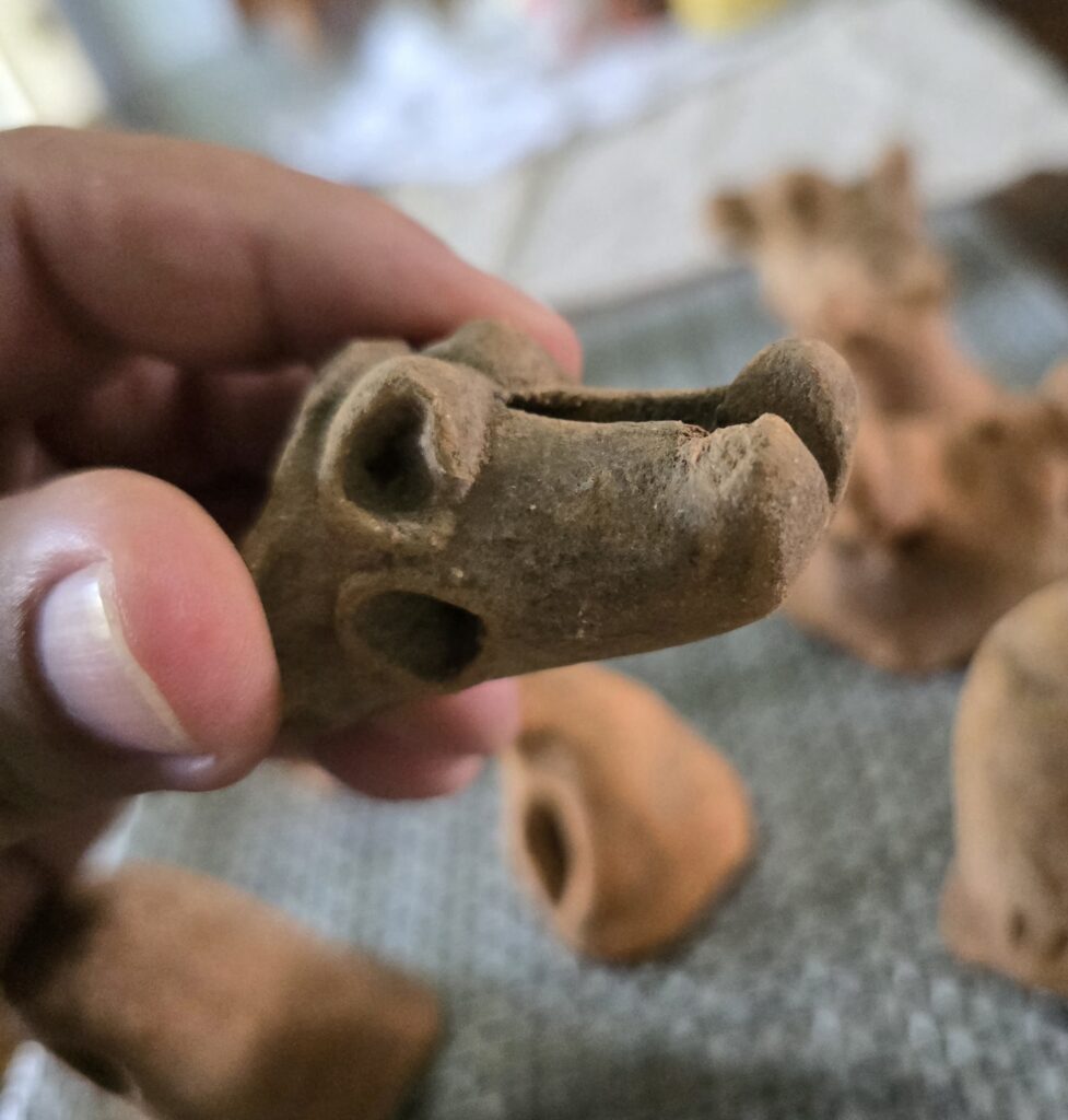
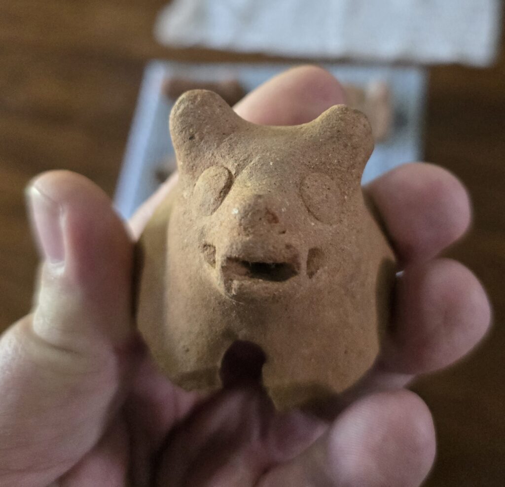
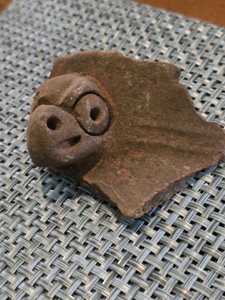
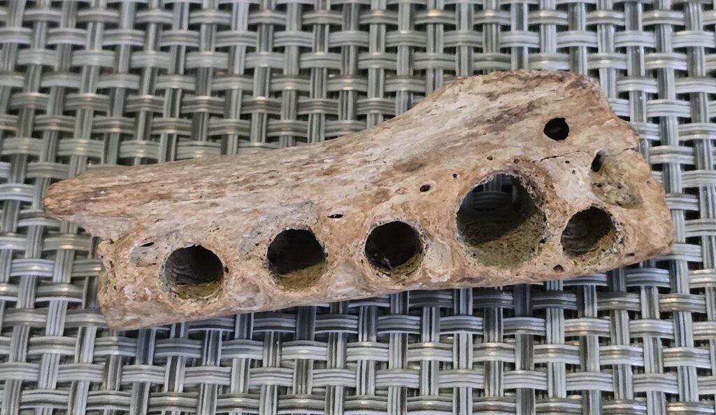
Figure 8 Flute made out of a human bone and figurines depicting common fauna of the region
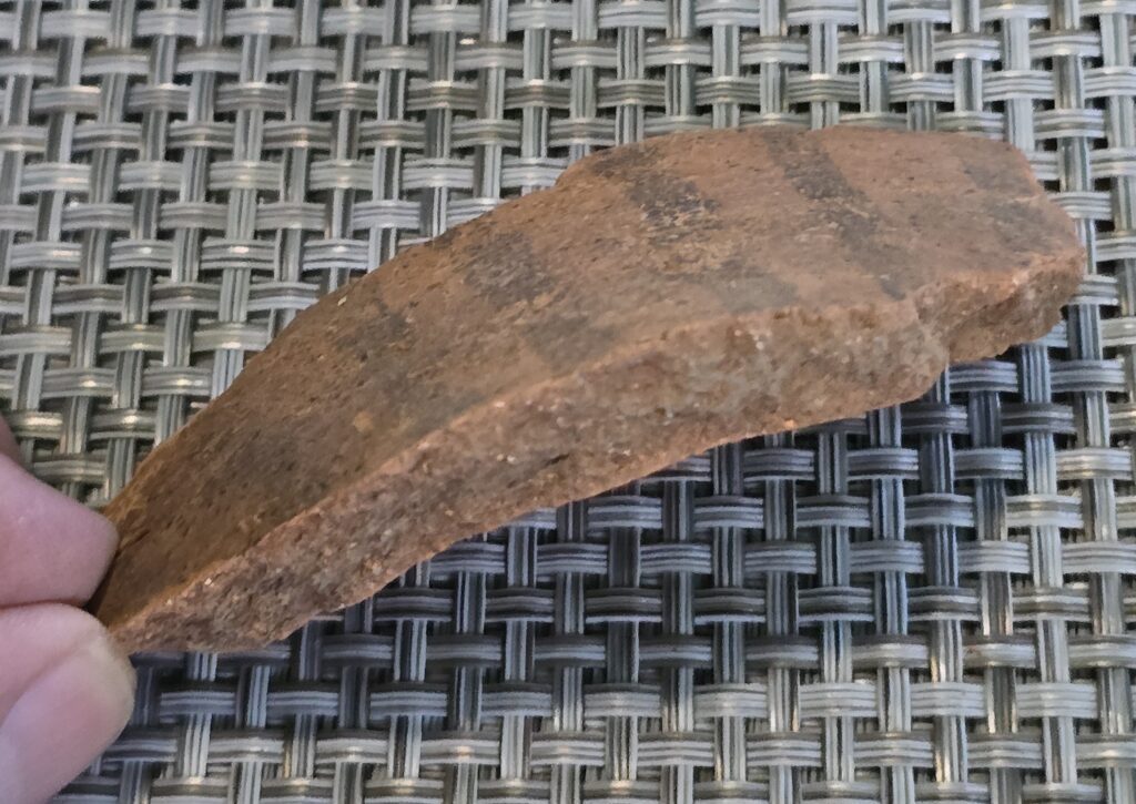
Figure 9 Polychrome sherd showing grey riverbank clay likely from the Ulua River Valley
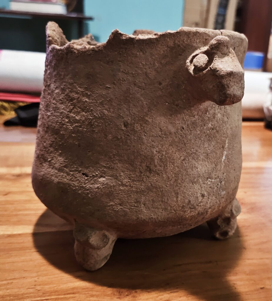
Figure 10 Early Selin period ( 300-600 AD ) olla identified by the three legs on the left and traditional Selin period (600-1000AD) olla with a flat bottom and clam shell “dipper” which was found inside.
In summary , It is quite clear that the Bay Islands and Masa in particular was not just the periphery of the Paya civilization but held considerable significance within it and played a large part in commercial and spiritual matters. I like how Dr. Whitney Goodwin summarizes in her 2011 Postgraduate Thesis :
“ The combined data indicate that the island of Roatán likely either represented a special physical location for the entirety of the northeastern population – in terms of
access to outside trade networks, resources, or perhaps of spiritual or ideological
significance –, or was inhabited by special group of individuals that enjoyed privileges
that those on the neighboring mainland did not.”
And ,
“ It seems highly possible that prehispanic Bay Islanders, because of their strategic
location and the developed nature of their ocean navigation skills, may have been
especially employed in trade or exchange networks. Although the direct nature of their
contact with other major groups is unknown, it is probable that much of their efforts may
have focused on the Ulúa Valley”
The End of the Paya
“ The Pech are of small or medium stature…they have long backs, a short neck,
prominent cheekbones, large lips, hairless, or a small, low, and flat nose. They are
generally very humble… The Pech rarely sing “
“They were noted for their skills as fishermen, their ability to make cables from tree bark, as well as pitch, tar and lime, and were also used for the transportation of goods and peoples on the seas “
Edouard Conzemius ….1928
The Europeans of course with their obsession to possess lands and loot the treasures of distant lands brought the beginning of the end to 1200 years of Payan civilization on the Bay Islands. By 1516 slaves raids by the Spaniards were regular ( the caves on Masa were used as hiding places no doubt ) and the Indians were taken first on the mainland around Trujillo to work and then later on to Cuba. By 1526 the Island population had nearly been depleted and Hernan Cortez put an end to the slavery and the Indians were allowed to live in peace on the Islands for a period and in fact supplied the Spaniards at Trujillo with most of the food . This peace lasted for about a hundred years until the arrival of the English and the pirates. The Spaniards felt that by denying the pirates food that they would stop using the Islands for shelter and so burning of crops was done.
The pirates in turn were afraid that the Indians were loyal to Spain ( actually this was to the contrary ) and burned whole villages ; the most notorious incident being at Roata’ ( todays Pulpit Rock )and also Masa with 14 families being left homeless by the Dutch pirate Van Horn in July and September of 1639. I would like to think that the Paya were able to hide out in the caves with their families to escape murder from Van Horn and his men.
The poor humble , capable , peaceful Indians who merely wanted to farm , fish and trade were again caught up in the middle of European ambition and greed. The few that were left died of disease or left for the mainland where the largest Pech settlements were and still are today.
Eyewitnesses from 1742 when the English arrived to set up their base mentioned that one or two lived in the area , no more than two families.
Literature cited
- Archeological Investigations in the Bay Islands , Spanish Honduras
William Duncan Strong , publ. Smithsonian Institution February , 1935
2. On The Aborigines of the Bay Islands ( Honduras )
Edouard Conzemius , 1928
3. The Bay Islands , Gulf of Honduras
R W Feacham , 1940
4. Archeaology and Indigeneity , Past and Present : A view from the island of Roatan , Honduras
Whitney Goodwin , University of South Florida , 2011
5. 1993 Northeastern Honduras. In Pottery of Prehistoric Honduras: Regional Classification and analysis
Paul F. Healy
6. Pottery Designs as Sources of Information about Past Environments on Roatán Island, Honduras
Whitney Goodwin and Christian Wells , 2012
7. Historical Geography of the Bay Islands , Honduras
William V. Davidson , 1974
8. Cultural Landscapes of resilience and vulnerability : The Selin Farm site , North Eastern Honduras
Leslie A. Reeder-Myers, Whitney A. Goodwin, Alejandro J. Figueroa, Alejandro , I. Domic & Juan Carlos Fernandez-Diaz 2022